Wetlands Policy in Virginia (Part 2): Pleasure House Point Mitigation Bank Controversy
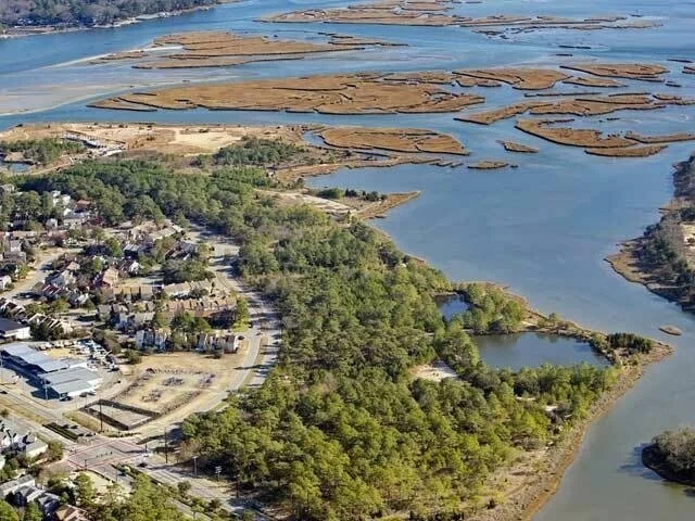
Pleasure House Point (Photo Credit City of Virginia Beach)
The Marsh Under the Forest: Pleasure House Point and the Limits of Permanence
In March 2025, contractors for the City of Virginia Beach cleared maritime forest along the Lynnhaven River near the Pleasure House Point Natural Area. Crews cleared about eight acres and removed more than 5,200 trees by the end of the month to make way for a wetlands mitigation project. To many neighbors, this looked like a city destroying nature. To the city, it looked like restoring the historic wetland environment. Both views hold up, and that is what makes Pleasure House Point the clearest local example of the questions we raised in Part One: what "no net loss" measures, where replacement happens, and how long it has to last.
A Forest Made by Accident
Pleasure House Point's forest is a human artifact. In 1954, Princess Anne County, the Virginia Beach Erosion Commission, and the U.S. Army Corps of Engineers designated the area as a spoil site for dredging the Lynnhaven Inlet. Before the 1970s, the site was a partially wooded inlet over-wash area with a broad expanse of wetlands. Between 1971 and 1972, over one million cubic yards of dredge material was placed over the wetlands, raising ground elevations roughly three to four feet and filling all of the historic tidal wetlands. Photos from the past can be found in the original Pleasure House Point Mitigation Bank Prospectus, showing us what used to be going back to 1937.
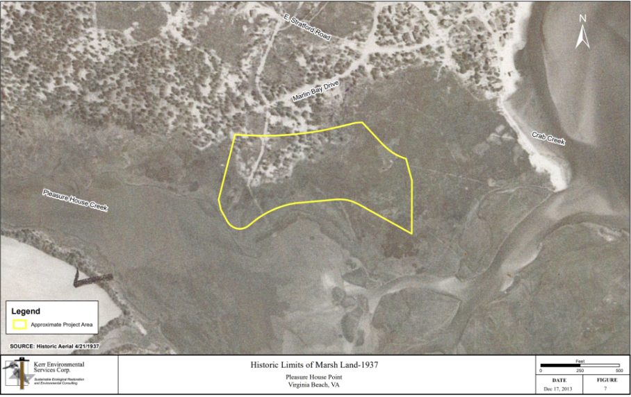
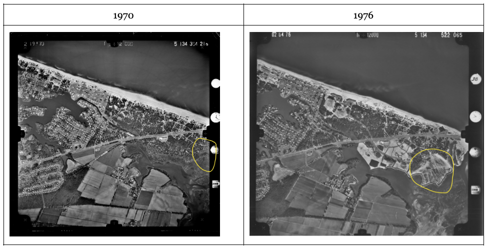
The Hampton Roads Planning District Commission holds a vast library of historic aerial photography covering the Hampton Roads region. Wetlands Watch requested photography of the Pleasure House Point area to look at changes in the area over time. In 1970, one could see the rich and expansive extent of the tidal wetlands on the Lynnhaven inlet. By 1976, the next year that HRPDC’s library covers, we can see the extent of new development and fill from the USACE 1970-71 project changing the shoreline as well as new subdivision around Marlin Bay Drive.
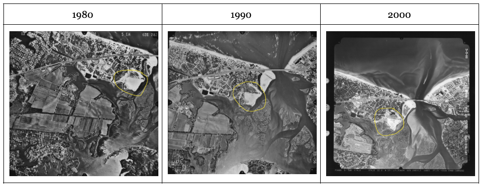
It took awhile for the maritime forest to grow, because the dredge site was actively disturbed with people traveling with cars over it. We started seeing grasses and shrub vegetation begin to grow in 1990, though a drainage pond in 2000 reduced the extent.
The forest that grew on that fill was opportunistic: loblolly pines and understory species colonizing sandy ground that humans had lifted out of the tide's reach. By 2012 the property stood to fall into the hands of developers who planned to build on it. The city and its partners preserved it. Virginia Beach worked with a local land trust and nonprofits to protect 118 acres from development, and the wetlands mitigation bank project has been planned for the site since that acquisition.
This is where the argument over "native" gets complicated. The city's position is that the forest is not the site's natural condition. Opponents argued something that deserves a serious hearing: a member of No Build VB Wetlands told council that tidal wetlands are not the only threatened maritime habitat in the Lynnhaven River Basin, and that the plan destroyed something the city had pledged to protect. The dispute continued after the trees came down. Four plaintiffs sued the Army Corps, claiming the project unlawfully harmed wildlife and public access to the park.
Both sides are defending something real. The harder question is which baseline restoration should target when every candidate baseline was shaped by people. We filled the marsh, the forest followed our fill, and then we grew attached to the forest. Mitigation policy has no clean way to weigh an accidental ecosystem that people love against an original one that regulators can count. Virginia law measures tidal wetland acreage and function. It does not measure twenty years of neighbors walking the same trail.
The Cost of Keeping Channels Open
The fill at Pleasure House Point came from a problem that has not gone away: the Lynnhaven's channels keep filling in, and the sand has to go somewhere.
Keeping the waterways navigable is expensive, and Virginia Beach has pushed much of that cost onto the people who benefit most. City Council adopted the Neighborhood Dredging Program in 2011. It operates as a Special Service District program, requires at least 80% resident participation, and imposes a special tax to fund dredging. Waterfront property owners agree to a surcharge on their real estate taxes, and the city cost-participates by dredging a channel from the main navigation channel to the neighborhood system.
The disposal side is where the pressure is building. The city has been using the Whitehurst borrow pit for dredged material since 2012, but it is reaching capacity. The city's proposal to fill the nearby Oceana borrow pit drew neighborhood opposition, and the alternatives are costly: private dumping sites about 20 miles away could increase disposal costs by 180%, and the city manager said the city would likely scale back neighborhood dredging and raise the special service district tax as a result.
This connects directly to the bank. According to its designer, Pleasure House Point's credits provide mitigation for City projects and neighborhood dredging projects for impacts to tidal wetlands within the Lynnhaven River Watershed. The loop is hard to miss. Dredging buried a marsh in the 1970s. Unburying that marsh now generates credits that can offset wetland impacts from future dredging. Meanwhile the city is running out of places to put the sand.
That points to a policy opportunity. Nearby marshes are losing elevation to rising water. At the confluence of Pleasure House and Crab creeks, a marsh island has about 2.4 vegetated acres as of 2025; without restoration, Corps projections show that shrinking to half an acre by 2090. Clean dredged sand is a resource that marshes like this could use to persist in place. Virginia's dredging, disposal, and mitigation programs are still managed as separate budgets and permits. The exploration of beneficial use of dredged material for marsh elevation deserves to be treated as a core resilience strategy, with the permitting and funding to match.
How the New Hierarchy Shaped the Decision
In Part One, we noted that Virginia revised its tidal wetland compensation order in early 2025. On January 28, 2025, the Marine Resources Commission adopted updated tidal wetland mitigation banking guidelines and a revised compensation policy, directed by 2023 legislation. Under the updated sequencing, the preferred order is available tidal wetland bank credits in the project service area, then an approved in-lieu fee program, then on-site or approved off-site mitigation, and local in-lieu fee payments only in limited or exceptional circumstances. The amended policy took effect February 1, 2025.
It would overstate things to say the new hierarchy created Pleasure House Point. The bank predates it: the city received Army Corps permitting in 2018 and recorded a banking instrument in 2020. What the hierarchy did was formalize a direction that was already reshaping the market, and Virginia Beach walked straight into its weak spot. A bank-first system works when banks exist where impacts happen. In the Lynnhaven, there was one private mitigation bank available, but the City opted to move with the construction of its own.
The city's options in late 2024 show what that gap looks like in practice. Its preliminary estimate of tidal credit needs was 6.947, which exceeded the total credits at the New Mill Creek Tidal Mitigation Bank in the Elizabeth River Watershed. According to Virginia Beach, those credits were selling at $1.5 million each, putting the city's need at $10,420,500. Location mattered as much as price. The Corps, reviewing permits for the city's flood projects, was looking for mitigation within the Lynnhaven River Basin first so there would be no net loss in that watershed. The public works director told council the city had planned to buy credits, but the credits it was told would materialize did not.
The clock came from voters. The North London Bridge Pump Station and Tide Gate project requires 2.3 acres of tidal wetland credits, and the bank was framed as essential to completing projects within the 10-year timeframe of the Flood Protection Program Bond Referendum. Council approved funding in January, the new hierarchy took effect in February, and clearing began in March.
The result is a structure worth watching. Virginia Beach is now its own banker, and Pleasure House Point is Virginia's first municipal tidal wetland mitigation bank. Its credits are fenced for public use: they are intended for public works projects including roadways, stormwater, and flood protection, and cannot be used for economic development or public-private partnership projects. That restriction is good policy. It also means the city is the bank's developer, operator, and primary customer, with the Interagency Review Team as the only outside check on whether performance standards are met. Other localities facing the same shortage will look at this model. They should adopt the use restrictions along with it.
There is also a real upside here that critics tend to skip. Because the credits stay in the Lynnhaven, the functions replaced (water filtering, nursery habitat, tidal storage) stay in the same river system that loses them. That is exactly the functional continuity Part One argued for. Buying credits in another watershed would have satisfied the accounting and delivered nothing to the Lynnhaven.
Designed for Rising Water
Pleasure House Point is also the first bank in Virginia (that we know of) to be designed with sea level rise explicitly in view, and that shaped our position on it. At the January 2025 council meeting, Wetlands Watch stated that we no longer opposed the project, as we had in 2014, because it is the first wetlands project to include a sea level rise review from the Army Corps and will create a wetlands mitigation buffer.
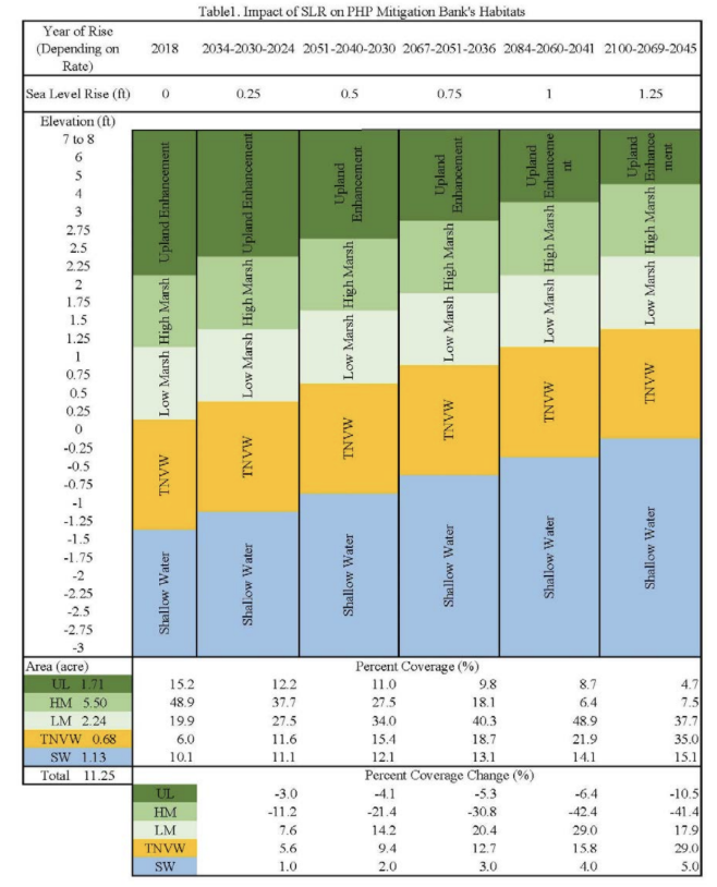
The planting plan reflects that design. Rather than building only low marsh, the site includes 67,051 smooth cordgrass plants in the low marsh zone across 3.5 acres, 87,712 salt meadow hay plants in the high marsh and upper high marsh across 4.5 acres. The gradient matters. Upper marsh and woodland zones give the lower marsh somewhere to move as water rises, which is the capacity most Lynnhaven marshes have lost. Lynnhaven River NOW estimates that with no way to migrate landward, the river could lose up to 80% of its remaining wetlands by 2100.
Can a Bank Exist in Perpetuity?
Design for sea level rise answers one question and sharpens another. Mitigation banks are sold on permanence. A permittee destroys a wetland today, and the credit purchased is supposed to stand in for that wetland in perpetuity. The impacts Pleasure House Point offsets are permanent: a pump station and tide gate will not revert to marsh. The bank is expected to hold up its end on the same terms.
The regulatory timeline does not match that expectation. About two acres of credit were released after planting, with staged releases over 10 years reaching the full bank, if monitoring benchmarks are met. Parks and Recreation will manage the site as a natural area preserve, with land-use restrictions protecting it from development. Ten years of monitoring and a conservation restriction protect the parcel. Neither guarantees that the parcel remains a functioning tidal marsh in 2080, and a 12-acre site has limited room to migrate before it runs into its own edges.
This is the gap we pressed the Virginia Marine Resource Commission (VMRC) on. Wetlands Watch and the Chesapeake Bay Foundation asked for explicit requirements that banks account for sea level rise and landward migration, urging "shall" instead of "should" where permanence and sea level risk are at issue. The Commission adopted the guidelines as staff recommended, and commenters asked it to revisit them if science or implementation experience shows stronger protections for long-term persistence under sea level rise are needed.
Pleasure House Point shows that sea level rise review is feasible. The next step is making it the rule. Several questions should be settled before the next wave of tidal banks is approved:
What does perpetuity protect? A conservation easement protects a footprint. "No net loss" requires function. Banking instruments should state whether the obligation follows the wetland as it migrates, and whether adjacent upland is secured to give it room.
Who pays when a bank drowns? Long-term management funds are typically sized for maintenance, not for adding sediment or acquiring migration space decades from now. If a bank loses function after its credits are sold, the permitted impacts remain and the replacement is gone.
Should credit accounting discount for risk? A marsh with no room to move is a weaker long-term asset than one with a migration corridor. Credit ratios or reserve credits could reflect that difference.
Looking Ahead
Pleasure House Point began as a marsh, became a dredge disposal site, grew into a forest, and is now a marsh again, this time by design, with many eyes on it and with an accounting ledger attached. Each change reflected what people needed from the place at the time. Rising water will force the next change whether or not policy plans for it. The question for Virginia is whether its mitigation system can treat wetlands as landscapes that move, and write that movement into the promises banks make.
In Part Three, we will walk through how a mitigation bank is created, what to look for in a Prospectus, and the questions worth asking when a bank is proposed in your watershed.
